Some Tile Servers may have an addition index. FetchMap refers to this as a Data Field Index, and uses the symbol {D} in the URL. See below for more details.
Base Map & Transparency Layer
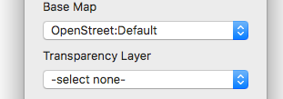
FetchMap allows you to load a Base Map from one TMS and many Transparency Layers from other TMSs.
In the example to the right, from the Control Panel, the Base Map is a satellite image, the Transparency Layer is the Administrative Boundaries provided from the Open Street Map (OSM) project. The slider changes the opacity of the transparency.
Editing the Data Field Index
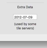
A Data Field Index are often used when one server serves up many maps. For example, a library with a large collection of old maps may assign each map an ID number. Or a weather service may add the date to each map.
In FetchMap this changing field is indicated by a {D} in the URL. You can then go to the Customize Window, and click on the Save ... & Tile Cache tab. On this panel there is a field marked Extra Data, which can be edited. Note: after editing this field you will want to click on the Refresh button, so you are getting all you tiles for the same map.
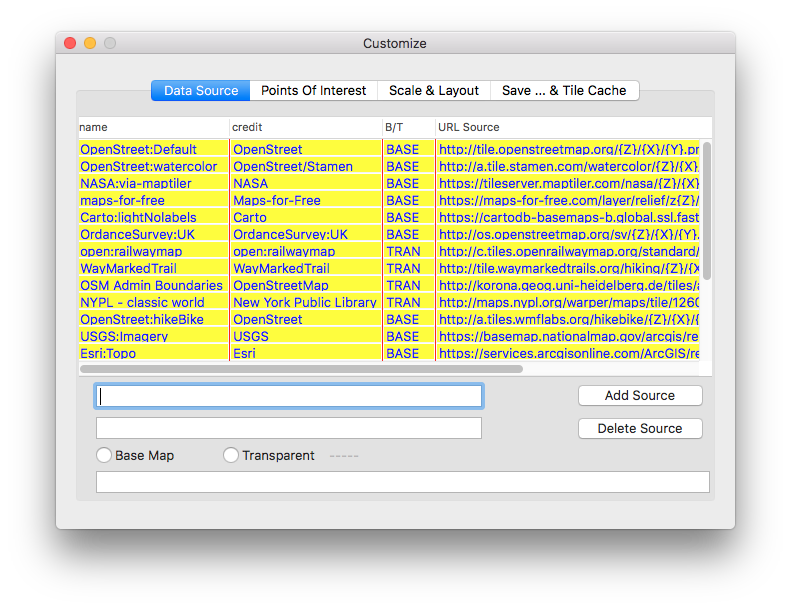
Adding and Editing Map Sources
To Add and Edit Map/Data Sources, click on the Customize button on the Control Panel. Then select the Data Source tab. A table displays the currently available Tile Map Servers is then displayed.
You can Add, Delete & Edit Sources
- Add Source: Click on the Add Sources button then edit; name, credit, Base/Tran, and URL of the new source.
- Delete Source:Select a source from the table by clicking on it, then click on the Delete Source button.
- Edit Source: Select a source from the table by clicking on it, then edit it.
- Restore Defaults: If any of the original source have been deleted, you can restore then by pressing the ⌘D, or by using the main pull-down menu, Restore Defaults.
Note: Sources marked in yellow are the original sources provided with FetchMap. These are here to get you started and to serve as examples.