Mt. Cube - South and West side - February 15
Again I took myself to breakfast before starting the hike. I should only
do this if I am early - and again today I am not. But I enjoyed it in December,
and so today I am breakfasting on the counter at the Fairlee dinner. The
diner is such an active place. I really enjoy being here and watching
old time Vermont woodsman sitting and explaining ice and trapping to
their teenage boys - who all look like they have heard it scores of times
before. There are families with pre-schoolers and grandparents, men and women in
hunting caps, and even that variety which look like they have escaped from the
cities, as well as every other combination.
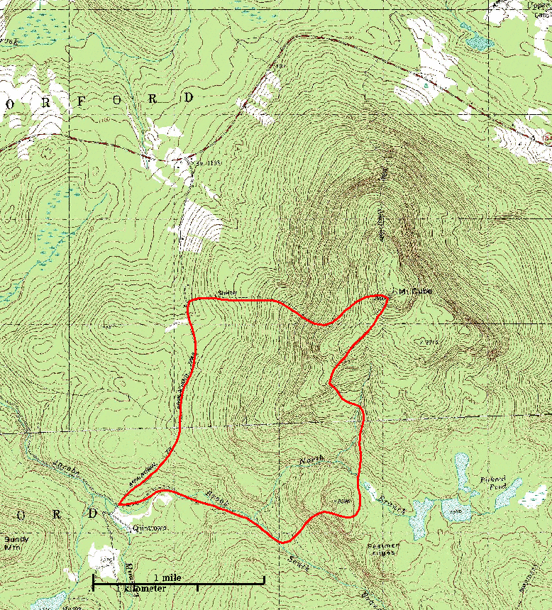
I am planning to start my hike in Quint-town, in Orford. I have read that
Quint-town really was a town at one time, but there is no evidence of that
now. If there was a town here the forest has reclaimed its ancient right.
Last summer Will hiked solo from here to Hangover. I had expected to start
in the same place as he did. But the road was not plowed to the end
and so I parked the car half a mile short and hike in.
I start on the old turnpike which goes up through the pass with
Smarts to the south and Cube to the north. It is used by snowmobiles,
so the progress for the first two kilometers is quick and easy. I have my snow shoes
strapped to my day pack as the old pike follows Jacob's Brook.
Finally I reach the trail junction, where the Appalachian Trail (AT) crosses the old turnpike,
or today where the snowmobilers cross the path of the snowshoers.
It was here that Will headed south. Instead, I am turning to the north to climb Mt. Cube.
Someone has been up this trail in the last week or so, wearing snow shoes,
so I can just wear my trekkers to start with. Who ever it was who left
those tracks lost the trail a few times, so I make a point
of watching my blazes. The white blaze of the AT can be a bit
hard to pick out at times with all the trees plastered with snow.
A kilometer up the trail, after passing Eastman's Ledge, I find that the
tracks I am following are more often then not filled in with snow. The
higher I climb, the thiner the vegetation and the more exposed the terrain
is to wind. It is a quite day now, but tracks in the snow are more easily
buried here. Still, I have now given up on following the snowshoe tracks
of a week ago. That phantom hiker tends to miss turns in the trail. I'll
stop when the tree branches are too close together and look to see a gap off the the
left where the trail is going, yet the prints in front of me wander around
in the tangle for awhile, usually rejoining the trail in a few hundred meters.
I have taken off my coat by now. The temperature is about twenty, but it is hard
work climbing. In fact, my back is wet with sweat because my pack has trapped
it there.
At a little over an hour I reach the turnoff for the "Hexacube Shelter". I'm
tempted to turn off and see it, but I've got my nose pointed towards the
summit, and it is hard to turn aside.
I crossed some moose foot prints in the snow. These are huge circles 25 centimeters
across (10 inches) in the snow, and a meter deep. I am surprised how regular
and symmetric the spoors are, and I think that the moose might be envious of my
snowshoes. He/she may have long legs, but the snow is deep and every step must
be a lot of work. It is a lot of work for me and I am only sinking in
ten to twenty centimeters each step.
As I climb I come to areas which are more and more exposed and at times I take
off my snow-shows because I am clambering over bare rocks and I think that my snow shoes
may only tangle me up here. I do put on my trekkers again, because often the
rocks are encased in ice. Up through the krummholtz. I am increasingly out on
ledge and exposed. But it is such a beautiful day and you can see forever.
Finally I reach the summit, marked the same tail signs and markers
I saw in December. I sit on my
snowshoes and pulled a thermos out of my pack. The hot tea seemed like such
a good idea when I was in the kitchen this morning, but right now I am hot and
wish I had something cold to quench my thirst. So I fill my cup with snow and pore the
hot tea over it. The iced tea is just the thing, and this technique is also a
liquid multiplier. I have brought half a liter of tea, yet I can drink a full
liter of ice tea! Actually, as I cool off and enjoy a Gerona bar I sip a cup
of tea hot too.
The view is stunning, even if I saw it two months ago. To the south is Smarts,
Winslow, Holt, and Moose. In Vermont I can see all the way to Ascutney.
Killington, with its distinct ski slopes, is very clear. To the west-northwest
is Mansfield.
Leading off the summit to the west is the new "Cross Rivendell Trail". Rivendell
is the Orford NH - Fairlee VT school district and this trail span the two towns.
I was toying with the idea of going down the mountain that way. But it is not clear
on my map how I would return to Qunittown, where I left the car. Also I wondered
if this trail would be as well marked as the AT, foolish me. A women was coming
up that trail and I asked her how well it was blazed. She shrugged, and then I
realized that of course she would have left footprints. So I head west and down
off the peak on the Rivendell trail.
As soon as I reached the edge of the ledge I realized that my concerns were
unfounded. This seems to be the preferred route to climb Cube. Snowshoes had
tramped a smooth, firm path such that I went down wearing my trekkers - for there
was still some ice. The drop was steep, but clear and easy. The trail drops 500 meters
in 3 kilometers. I think that may be a stiff climb, be a simple descent.
At the base of Cube I came out on Barker Farm road, a dirt road. My car was
about 2-3 kilometers to the south of me, but I knew that Barker Farm didn't
connect to the Quint-town road. Still, I have an old AT map which showed
the trail going this way before it was rerouted over all the peaks. The
alternative is to walk north, out to the highway, down to Qunittown
Road and in to my car. That is about five miles - but a simple five on road.
Still, I took the chance that this dirt road would not just end, and
struck off south.
The dirt road wound through the woods and eventually ended at a sugar grove and
shed shack after about a mile. But then I noticed a snowmobile trail, and realized
that it was on an old class IV town road. These are still public right-a-ways,
but generally unmaintained. It was only ten more minutes and I was back to the
car.
|
| place | time | miles | km |
| Quint-town | 11:25 | 0 | 0 |
| AT | 11:45 | 1.1 | 1.7 |
| Hexacube | 12:35 | 2.4 | 3.9 |
| Summit | 1:40 | 4.0 | 6.4 |
| Start Down | 2:00 | 4.0 | 6.4 |
| Barker Farm Rd. | 2:45 | 6.0 | 9.6 |
| Quint-town | 3:15 | 7.5 | 12.0 |
|