|
Mt. Cube - Northeast - Jan 7, 2010
Will & myself
Our day started with a little side trip across the river, into
Vermont where we stopped at Isabell's Cafe for a late breakfast.
In fact we were a little too late for even the latest of breakfasts,
and had to be satisfied with a lunch. But the vegetable soup was
tasty and hot and the sandwiches fueled us and so we continued on
to Orford.
As we wound our way up the Governor Meldrim Thomson highway, Will and
I discussed the "The Pledge". This pledge was started by Governor Thomson
(1973-9) and has been forced onto almost every gubernatorial
candidate since then. The pledge was simply to "Axe the Tax".
I am told that Thomson's whole campaign strategy was to show up
at local fairs, wielding a hatchet and ranting about taxes. Remember this
was at a time when the state was almost completely Republican, and his
rant was against big spending Republicans.
No new taxes in New Hampshire means that we have a lot of old taxes that
are continuously tweaked to somehow raise the funds needed to run the
state. And then there are fees for everything. But this essay is
about a hike.
When Mount Cube finally came into view the first thing that struck me
was that there is a definite snow- or frost-line. At the base of the mountain
we see woodlands with a blanket of snow, but at higher elevations the
mountain is encrusted with it. It looks different, but it is
hard to quantify what that differences is. I mentioned it to Will who
suggest that what we are really seeing is the change in the type of trees
from the deciduous low land to the heartier hemlock and spruce up higher.
The conifers can hold the snow in their branches.
The highway department has plowed off an area near the trail head
for us to pull into. It is a rough parking area with the ruts of
past cars and truck frozen into the terrain. Muddy tracks of November
or December are iron ruts until the spring thaw. We walk over to
the trailhead and discuss what to wear on our feet. There is
only about four inches of snow but Will announce without hesitation
that it is snowshoeing conditions. I am more hesitate, since last winter
I made an ascent up with trail with only my trekkers. But today we
don snowshoes.Will tells me this is really his first snowshoe hike.
As we step off the road and into the woods I can imagine that this was
pasture land at one time. Gilmans Corner, 300 meters from here, must have
had enough people to justify a name. There are a few houses there
today, but the area is dominated by summer camps. Merriwood Camp
on Upper Baker Pond just to the north, and Pemigewassect Camp on
Lower Baker Pond, a kilometer east.
The woods are a mixture here, a glen of hemlocks, a knoll of white pines,
a gentle slope of maples and beaches. We cross a stone wall at a wide
gate and stop to examine the track of mice who have darted across
the gap and then disappeared into a labyrinth of tunnels beneath
the walls. Beyond here is also a cellar-hole, but that is not
todays outing.
Will is breaking trail and setting a good pace and I am happy
to just tramp in his foot steps. Walking in snow without snowshoes
takes a lot of concentration, for you have to aim you feet at the
marks in front of you, or at Good King Wenceslas said
"Mark my footsteps, my good page
Tread thou in them boldly
Thou shalt find the winter's rage
Freeze thy blood less coldly."
In his master's steps he trod
Where the snow lay dinted
Heat was in the very sod
Which the Saint had printed
... well, I am not certain how much heat is left were the snow was dinted,
but if they had been wearing snowshoes...
Occasionally I'll walk next to Will, to make it easier to talk. But most
of the time I'll mark his footsteps.
We cross a snowmobile trail which I've found marked as a class IV road
on a 1928 USGS map. We cross the northwest shoulder of Nichols Hill and
the abruptly drop down into a dell containing Brackett Brook.
The Brook is frozen in most places, but it is filled with boulders and
we can hear the rapids under the ice. We debate between trying to cross
on the rocks or across a flat frozen pool. The rocks are glazed with ice,
and it is not clear whether the steel cleats on the bottom of the snowshoes
would help, or would the long shoes tangle us up.
Will ventures slowly out across the flat ice, and then detours away
from creaking ice near where the stream plunges over an ice dam.
Since he has pioneered a safe crossing, I mark his footsteps and we
are soon climbing Mount Cube proper.
At the one hour mark we stop for tea. I've brought my old space blankets
(Christmas 1976?) which we unfold just enough so we can both sit on it.
We are hot from our work, and so add snow to the tea which I pour from
a thermos. The snow cools it and gives us more to drink.
We are constantly climbing from here to the peak and it is my turn to
break trail. I am not certain how deep the snow is here, most certainly
a lot more then the four inches by the road. We were at 900 ft elevation
at the road, and now we are crossing the 2000 ft mark. The woods are
still dominated by maple, beach and the occasional oak and birch.
With snowshoes your foot prints are nearly as long as your stride length -
especially when headed up hill. Our snowshoes are a model called the
"Sojourn 25", which means that they are 25 inches long. So the second
person it not aiming for the "dint" of the leader footsteps, rather we
leave a continuous trench, two shoes wide and three miles long. We
are the first ones up since the last snow fall, but most of the time
there is at least the suggestion of a crease in the snow to mark the trail.
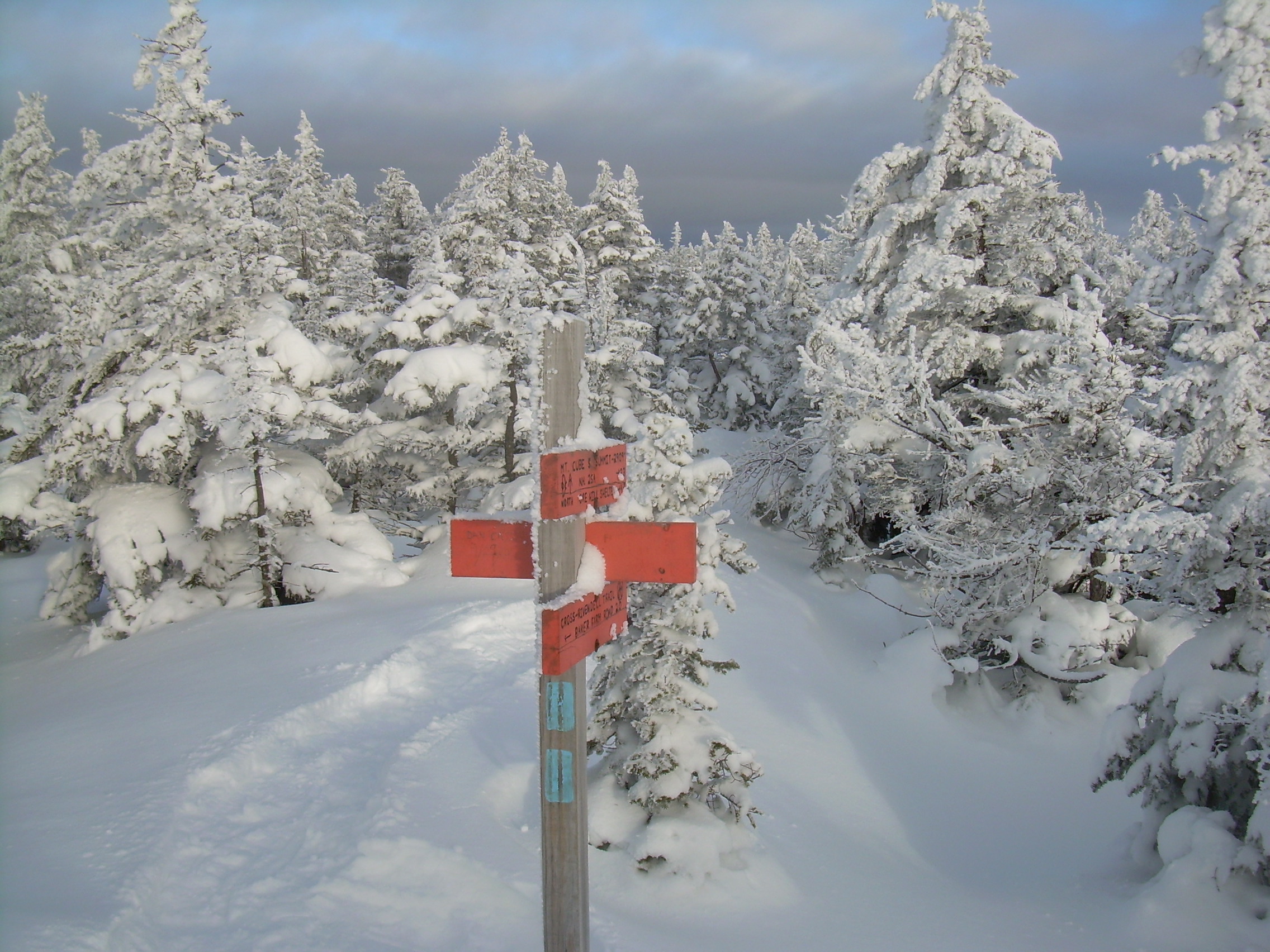
The alternative is to look for the White Blaze of the Appalachian Trail,
but to be honest, the white blazes look a lot like a patch of snow, a
mark most trees have.
There is a switch back, and we are heading almost due south when I hear voices!
A group is coming down from the peak, three snowshoers and a dog. Both
our group and their's promises the other group that we have broken trail
just for them.
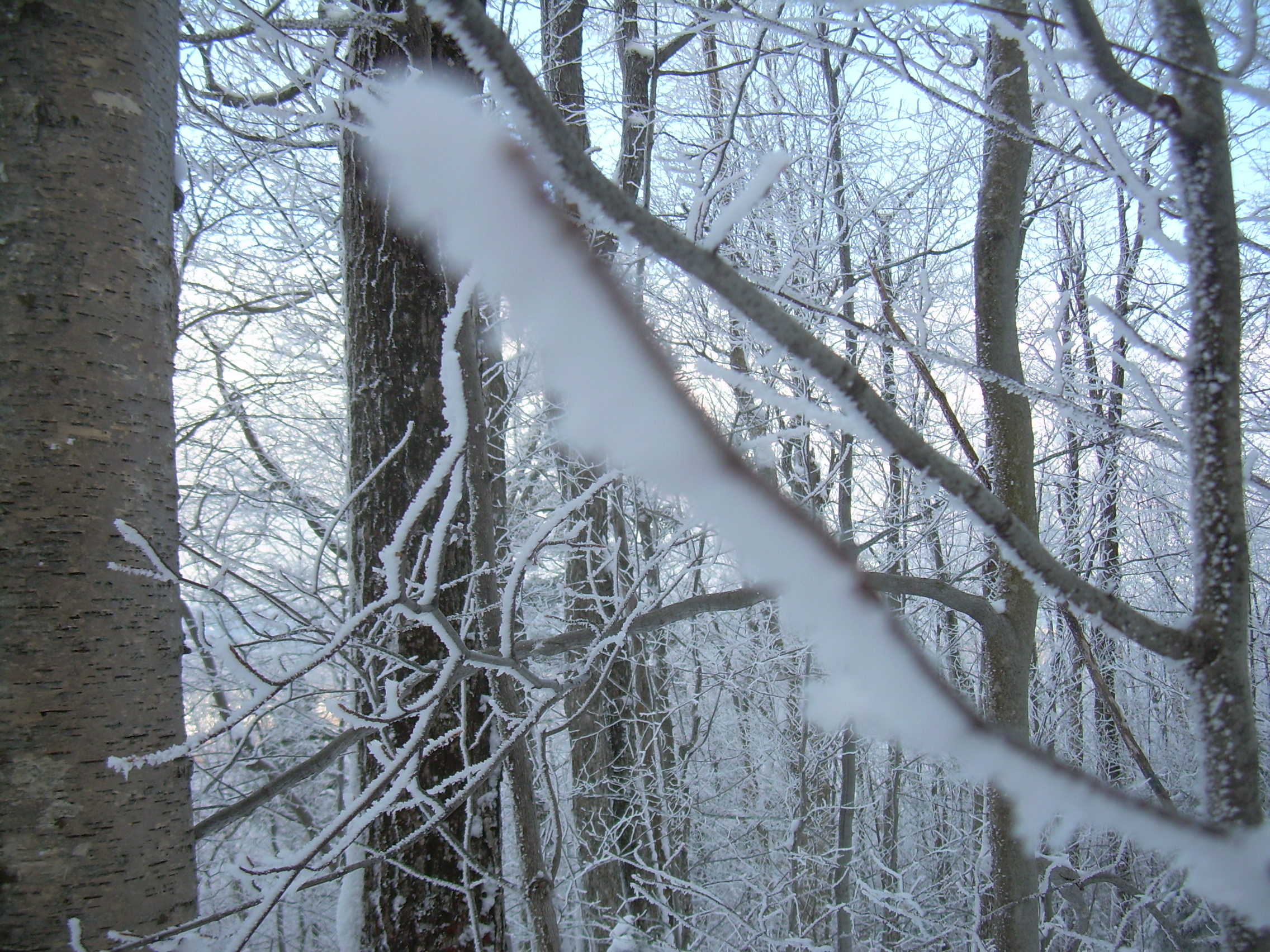
And now the trees are gilded with a hoarfrost. The word "hoar"
means grey-haired or even noble with age. A hoarfrost is a fuzz of a frost,
frozen water vapor instead of frozen water. It is the frost which accumulate
in your freezer, but out here it is a thing of beauty. We are crossing that
frost-line which we could see from the road, below us the snow filled wood,
above us, the frozen forest. It is frost which encased everything from tree
trunk to the tips of the most lofty twigs. But Will is also right. He
said that it was the line between deciduous and conifer, and in a
hundred meters we are surrounded by spruce and hemlocks.
One more switch back and we are headed northeast, just below the southwest
ridge of Mt. Cube. The trees are becoming shorter and they are crowding in
on our trail. We can also tell that the group who we met coming down
the mountain occasionally skied on their snowshoes. The two hour
mark comes, but we decide to just push on.
I was here last winter, but that was in the first week of December and
there was a fair amount of ice on the trail and some patches of snow - but
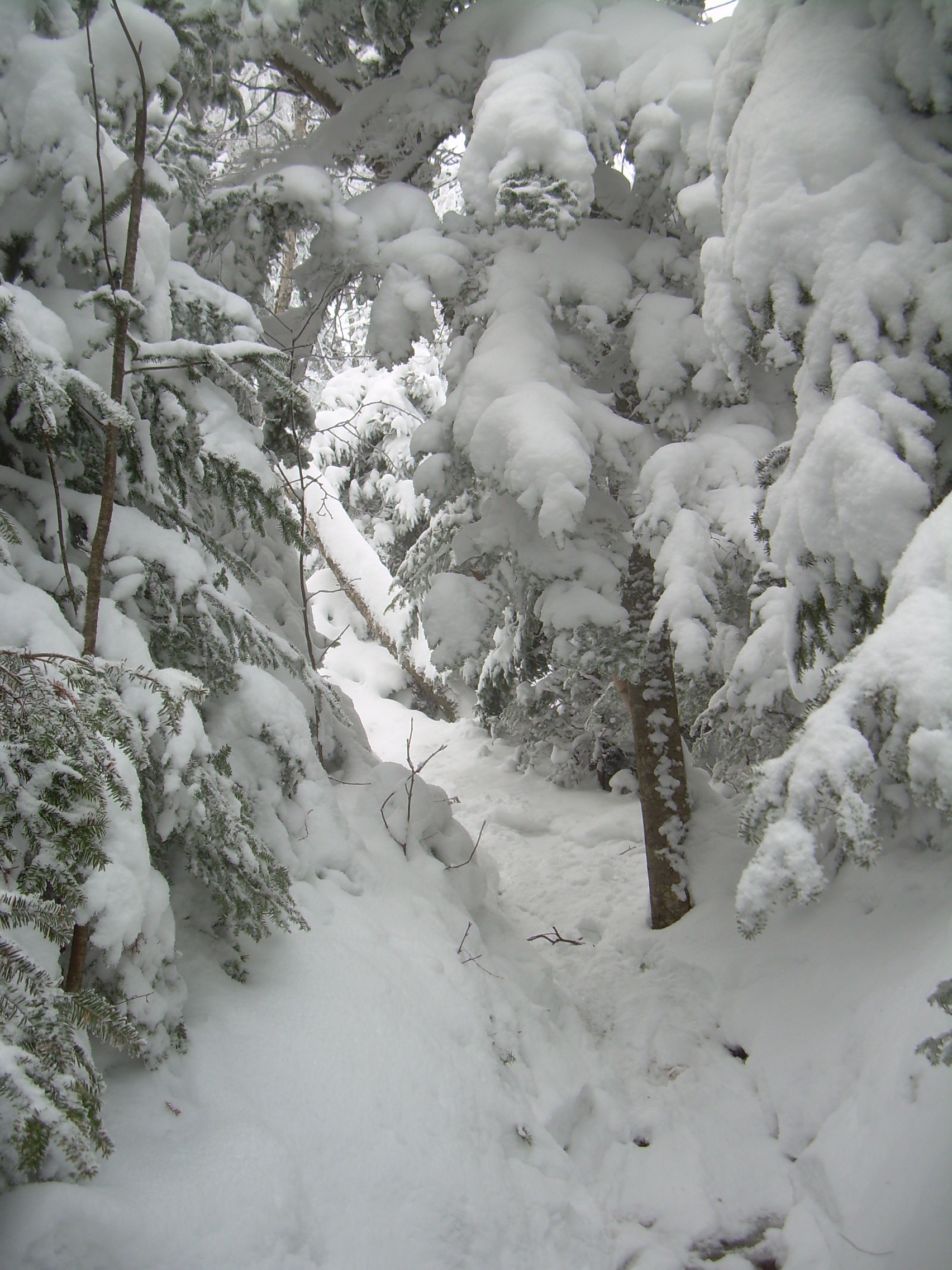
nothing like now. As we climb past the 2700 ft mark the trees are
encased in thick coats of snow. Think about the fur coats in the wardrobe
at the portal of Narnia, now imagine that those coats are white and worn
by dwarf trees. The trail becomes a miniature canyon in the snow, for the
dwarf tree of the Krummholtz are crowded tightly together and there
snowy coats merge into a nearly continuous wall.
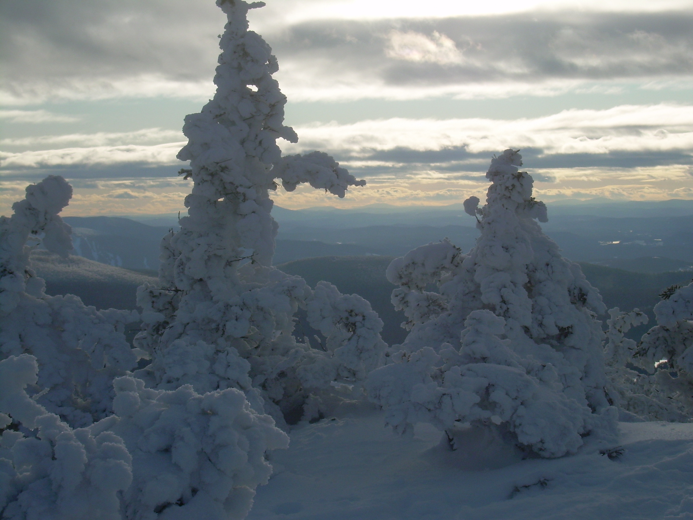
The top of cube has two peaks. To the north is a ledge which looks out
upon Mt. Moosilauke but to the south is the true peak. In between is
a saddle point, a ravine which is protected from the wind and thick
with stunted trees. The trail pushes into this saddle. We opt for
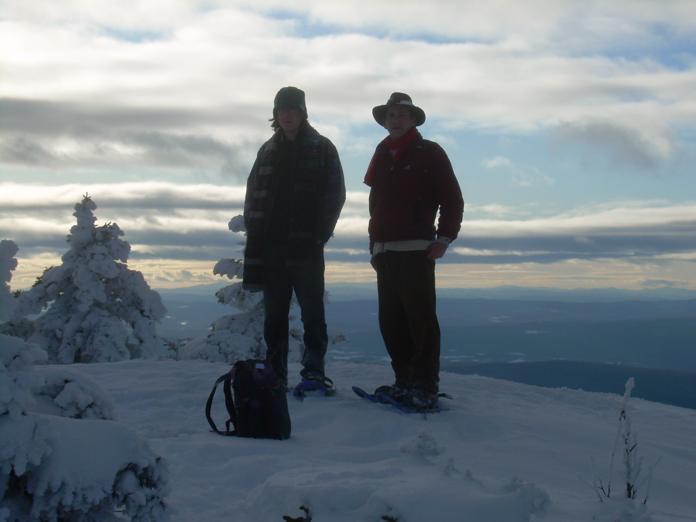
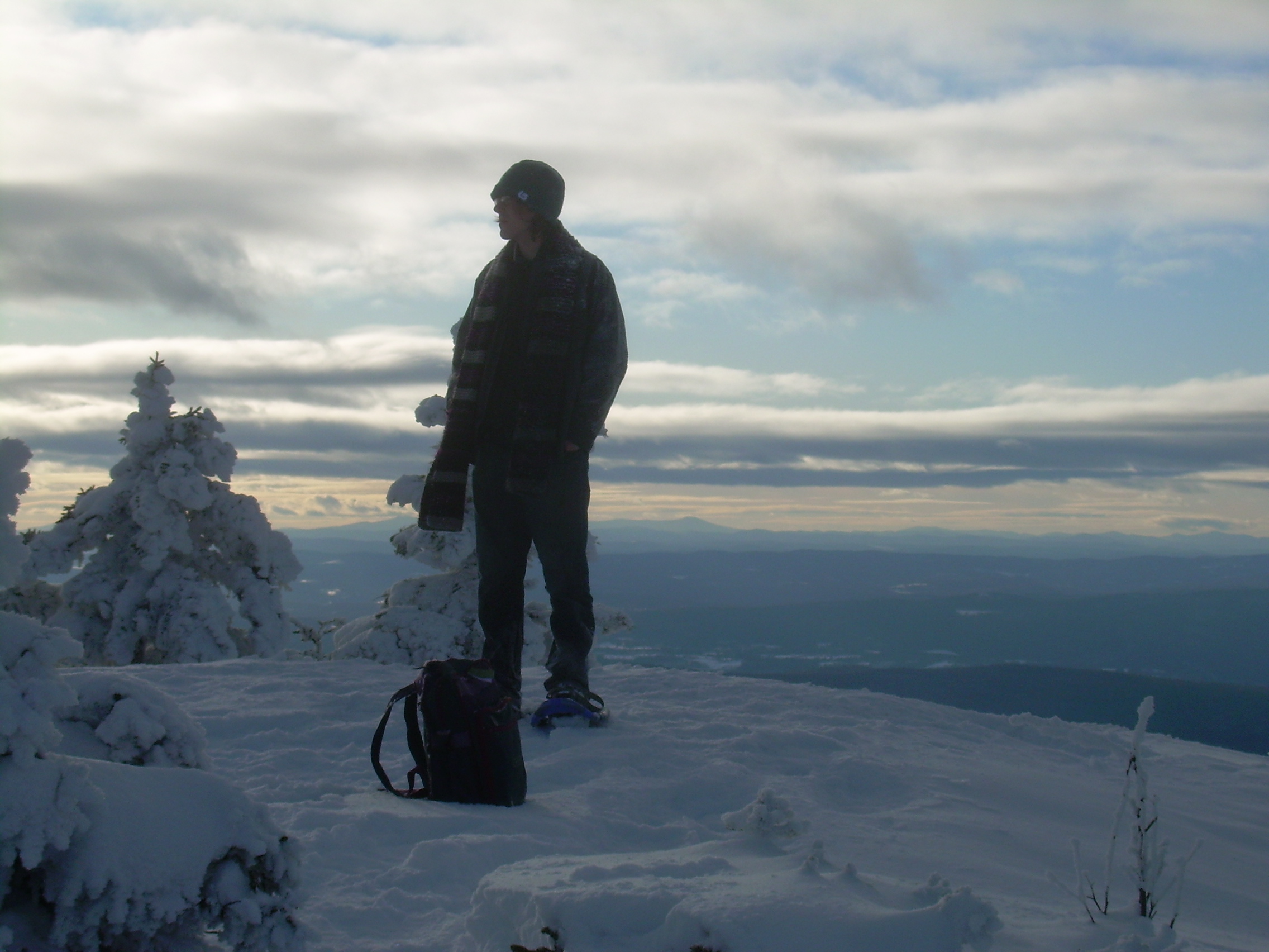
the south peak, the day is fast progressing, and top Cube at about 3:00.
The view is stunning. South of us Smarts, Winslow, Holt and Hanover's
Moose Mountain parade down the east side of the Connecticut Valley.
Across the River in Vermont is Ascutney with its distinct cone shape.
Further to the south west is Killington, not only the tallest peak in
that region, but uniquely identifiable by its ski trails. West of
us are the high peaks of the Green Mountains, Camel's Hump, Stow
and Mansfield. But the peak which is most interesting is the one
we are standing on top of.
How can I describe the trees and their coats? Like Christmas trees
decorated with mashed potatoes or whip cream? No, let me try again.
Mounds of vanilla ice cream? Food is not the right metaphor, for
purity and simplicity has to be part of the description. The snow
is more akin to cold clear spring water then to the food-like
soups or broth. But it
is not unfriendly, at least not on such a pleasant day as today.
So let me think about how this coat of snow was applied to the trees.
It did not fall on the trees on a cold and still winter's night. The
snow was sprayed on the trees by the whirl wind of a nightly storm.
The snow fell from all directions, plastering the bottoms and sides
and tops of every branch until every limb has a thick mitten and the
mittens merge into mounds of frozen cotton-wool, with a tree someplace
on the inside.
These look like the trees that Dr. Seuss might draw.
As Will said, clearly we don't climb mountains to get to the top,
because we end up spending so little time on the summit. And so
after a few minutes, before the sweat in our fleece have a chance
to chill, we start our descent.
Ten minutes below the peak we find a shelter spot in the Krummholtz
and sit. We drink tea and chew on granola bars. Here I also probed
the depth of the snow with a stick. It is over 30 inches deep.
I really enjoy Will's company on this type of outing. Much as I wrote
on our hike up the Franconia Ridge in July, his sense of pace matches
mine. We stop only briefly and we hold a steady cadence.
The descent is fast and easy. Down out of the evergreens, down past
the frost-line. Will tells me about some of his ideas for stories and
we kick around ideas about how it might twist and turn. In forty
minutes we are crossing Brackett Brook and continue our steady descent.
At one point I get off the broken trail to compare the stride length
uphill and downhill. My uphill stride length is about 24 inches, the
downhill is about 36. At first this seems curious, for my downhill stride
is even longer then when there is no snow
and I don't have snowshoes. But this is because the snowy trail is
so smooth and soft. It is a pleasure to plunge down the slopes.
Past the snowmobile trail, the old cellar and stone walls, and now
it is getting darker, for the sun has set. We haven't seen the sun
since we left the peak, for we have been in the shadow of the mountain.
But now it has stopped illuminating the sky and grove of hemlock is truly
dark. I'm not concerned. We have headlamps and I have never found it
difficult walking through the night in the woods of winter. The pure
white snow reflects even the faintest of light.
We come out on the road in a few more minutes.
I feel a bit tipsy after taking off my snowshoes,
a bit unstable on narrow feet. But as twilight is upon us we are
back in the car and it is time to head home.
| 